
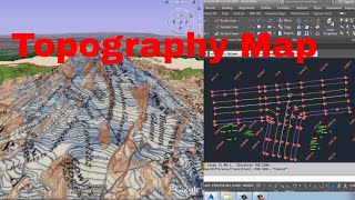
In this video, I explain how to create a topo map in civil 3d with connecting COGO points, in this video I didn’t use any surface or background contour line or surface simply I use some layers and feature line styles to create real level lines. in feature line, we can show up & down or real levels
hopefully, I explain very clear in this video how to connect cogo points in Auto Cad Civil 3d. if anybody has question about this lesson or others let me know in comments I will reply within 24 hours
finally, thanks for watching my video & don’t forget to like & share this to other
