
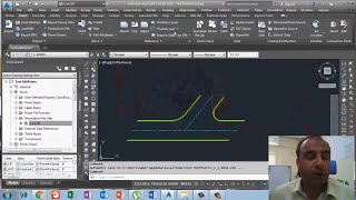
When Civil 3D objects or their labels need to modified, Civil 3D allows us to make many of the changes using familiar Auto CAD tools, such as grips or the properties palette. In this lesson, we’ll make some changes to a few point objects using these classic Auto CAD tools. On my screen is a drawing that represents a portion of a road intersection. As you can see, there are several points in this file. These were collected in the field so that we could create the geometry that we see on screen
#ErtugrulYouTubeRecord #ErtugrulUrdu aamirshahzad autocad AutoCAD Short Cut Calculate the Horizontal distance between 2 unknown points with triangle method in Urdu/Hindi Civil 3d Description Key Civil 3d Points Objects Convert coordintes KTM to Plant Coordinates conversition Ertugrul Ghazi Urdu ErtugrulUrdu hariri hindi IM-105 job in Dubai Job in Pakistan Jobs All over the world Jobs in Saudi Arab Land Survey land surveyor land surveyor career land surveyor job Land Surveyor job in Kuwait Land Surveyor Job in Saudi Arab land surveyor salary Leica FlexLine Leica TC405 Mobile App Quantity Surveying REM function in Sokkia Total Station Road Design Short Commands in Auto CAD Sokkia IM105 Sokkia TS Stake Out survey Surveying surveyor urdu Use of Ctrl key in AutoCAD Use of XClip command on XREF drawing in Auto-CAD Hindi/Urdu vibrocompaction video youtube youtubevideo
